One of the more popular hiking routes from the Chamonix Valley is the walk to the Albert Premier Hut or Refuge Albert Premier - high above the alpine hamlet of Le Tour at the head of the valley. The hut itself is situated at an altitude of 2702 metres overlooking the ice seracs and crevasses of the Glacier du Tour but despite the high altitude and spectacular position it is a fairly easy walk along a good path.
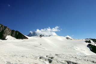
You can start the walk in Le Tour but it's a long day from there - most hikers to the Albert Premier take the gondola to Col du Balme up by the Swiss Frontier from where a good path leads in roughly a southerly direction at first to gradually ascend around the hillsides by an easy route. The first picture shows the col de Balme area from the early part of the route.
After perhaps a mile the path passes the Lac du Charamillon which is just above on the left and is a wonderully peaceful spot - this track can be busy during fine weather. A little further and the route tops the ridge ahead and turns to the left where spectacular views open up ahead of Mont Blanc and the vista down the Val du Chamonix.
There follows a short rocky section protected by a rope handrail - no difficulty - and the route heads on towards the Glacier du Tour over boulder strewn hillsides. At the glacier the path bears left up the steep moraine and meets the direct route from Le Tour which comes up from the right. Now a steady climb of the moraine takes us directly up to the hut which can be seen above. The last part is often snow covered but you don't go onto the glacier itself which is below on the right.
The views from the Albert Premier are stunning with the Glacier du Tour as a centrepiece. The high peak on its far side is the Aiguille du Chardonnet (3824m) while the rocky summit beyond the refuge is the Aiguille du Tour (3540m) - a popular climb from here. This ascent is not difficult but you need ropes as it goes onto the glacier where there is a crevasse danger.
The panorama across the valley is just as awesome with the jagged peaks of the Aiguilles Rouges rising from the wooded valley and the usually snowy peak of Mont Buet (3099m) topping the Emosson Peaks - a view which has accompanied us most of the way from Col du Balme.
On the journey back remember to bear right on the path after descending the moraine if you're getting the
gondola down - the path straight down does go to Le Tour but it's steep, rough and generally not as easy as the ascent route was. It is about 4.5km or a bit under 3 miles from the gondola to the refuge and the path climbs about 600m or 2000 feet in getting there. From Le Tour it's twice the climb.
A selection of high level routes to summits and viewpoints in the Alps in photo diary format. These routes are classed as walking or hiking trails rather than climbs and are not beyond the ability of the average hiker. Also included here is my 8 day journey between the Eiger and the Matterhorn undertaken in July 2007.
Friday 18 November 2011
Friday 4 November 2011
The Eiger Trail
The Eiger Trail route is described briefly in an upwards direction on day one of my Grindelwald to Zermatt trek but here is a more detailed description of one of the most enjoyable walks in the Jungfrau Region heading downhill from Eigergletscher to Alpiglen which is how many choose to do this walk. The lack of effort needed means one can concentrate on enjoying the stunning views! The following is an exerpt from Tales from the Hills.
I finished my meal of Schnitzel at the Eigergletscher Station restaurant and, shouldering my rucksack once again, ventured back outside. It was cool and breezy but the rain seemed to have stopped so I crossed the railway line by the tunnel entrance and followed the sign for the Eiger Trail.
The way led up a little past the hostel, giving the opportunity to go up onto the ridge crest itself where the original Mitteleggi Hut had been placed since the new hut was built on the Mitteleggi ridge on the far side of the summit. The tiny hut was locked up but I could look inside to see the layout. It was something of a museum piece and quite fascinating. A grand spot too with views across the Lauterbrunnen valley around over Kleine Scheidegg and down to Grindelwald on the other side. I was at about 7700 feet here so it was warmer than it had been on the Monchsjoch but the wind, if anything was stronger, the gusts threatening to blow me from the
ridge. I wasn't going to attempt to go much further up anyway, the way being barred by the huge rock pillar of the Rotstock rising up towards the top of the Eiger.
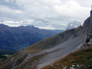
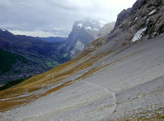
 After taking a few photos I went back down past the hut and joined the trail winding down to the right towards Grindelwald and the Wetterhorn. It was a clear well prepared and marked path leading at first below cliffs on the right and then past a cavern-like tunnel in the rock before heading down at a fairly easy angle across the screes below the North Face.
Descending all the time, the track led across a vast stone filled hollow. Down on the left were the meadows below Kleine Scheidegg with glimpses of the railway running through the trees beneath a long scree slope. Above on the other side, the slope rose to the base of grey cliffs which seemed to rise up forever, their tops hidden in the swirling cloud above.
As I neared the bottom of the stony hollow, there appeared a large number of small cairns on the hillside. I can only assume they were memorials to those climbers who lost their lives climbing the face. It was however, a strangely peaceful spot, the view over the valley tempering the harsh rugged scene. I was reminded of the dangers by a distant crashing above; rock fall, one of the main dangers of climbing here.
The way led up slightly before heading more steeply downhill. Here were 3 people coming up the other way, the first people I'd seen on the route. I said "Hi" as I heard they were speaking English but the 2 blokes were too engrossed in a heated discussion about where they were. The girl behind them gave me a despairing look. At least it was more or less impossible to get lost on this route, they'd reach the station soon then they'd know where they were!
Still arguing, they continued on up the trail completely missing the small group of mountain goats grazing a shelf of rough pasture above us. I was reminded of a misty day at Esk Hause on Scafell Pike when this guy in a group of about 6 had been telling his fellow walkers the way back to Langdale in a voice that could probably be heard there. I'd had to politely put him right before he led his group off into the wilds of Upper Eskdale!
Anyway, the route continued down towards Grindelwald with a great view to the Wetterhorn beyond. The path was now over grassy pastures rather than stones and dipped down steeply a couple of times to cross small rivers cascading down from the face.
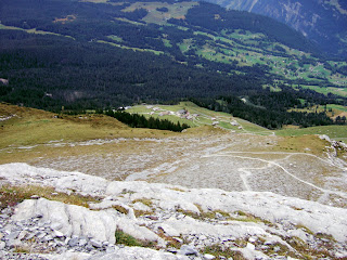
The rain had started again but was only light as the route began to traverse a wide ledge onto a rocky section below the Mittellegi Ridge. There were good views down to the valley from this bit and below an impressive waterfall the path veered off down to the left zig zagging steeply down. There were no difficulties however and I finally crossed a small footbridge over a mini gorge worn in the limestone by the river. The path I was on now joined another which crossed the hillside lower down.
For Alpiglen, I now followed this to the left, the other way leading towards Pfingstegg, doubling back below the route I had just descended. A short fixed handrail section over a steep bit and I was down into the pine forest before crossing a meadow to Alpiglen station.
The rain had just started up again as I boarded the train which was full of people returning from Jungfraujoch and Kleine Scheidegg. I managed to find a seat where I was duly entertained by a Japanese girl's efforts to photograph a dog on the other side of the compartment!
Start Eigergletscher 2320m >>> Finish Alpiglen 1616m >>> Distance 5km
Start Eigergletscher 2320m >>> Finish Alpiglen 1616m >>> Distance 5km
Subscribe to:
Posts (Atom)


